Boundary Survey
A boundary survey transfers property lines from a map or grant deed to the actual ground where you can see them. These are called “title lines” or what you really own. You need to know and see these lines so you can determine where to build and/or protect your property rights by viewing lines of occupation and possible encroachments.
Surveyors are not all created equal. What separates an accurate boundary survey from a substandard one is a dedication to due-diligence in the form of a thorough examination of all available records and evidence in the field. This requires a commitment to following the trail of evidence wherever it leads in order to ensure everyone’s property rights. Arizona Surveying has a long-established reputation of properly researching, establishing and marking property lines where they belong.
Your survey will start by simply providing us with the grant deed to your property which contains legal language describing what you own (legal description). From there we research public and private records that provide documented evidence of your property’s boundary location. Using that evidence, a field survey crew will visit your property to measure all existing monuments and evidence they can find. With this information we calculate corner positions, set new monuments if necessary and then produce a map of your survey.
For professional guidance and the public’s protection, The State of Arizona publishes a “Minimum Standards for Boundary Surveys” document which we closely adhere to and exceed in most cases and can be viewed here: https://btr.az.gov/sites/default/files/documents/files/ARIZONA%20BOUNDARY%20SURVEY%20MINIMUM%20STANDARDS%281%29_0.pdf
Property Lines
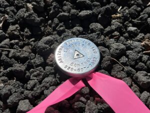
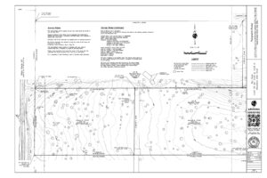
When surveying your property, we will recover, measure and verify the location of existing corner markers and when necessary, set new highly-visible corner markers at key locations so you can easily see, mark and occupy exactly what you own. The final step is to draw and file a map so there is a public record of your survey. If we see any potential encroachments we will locate and show them on the map.
Easements and Right of Ways
Easements and right of ways (roads, streets) have specific boundaries just like land parcels. Knowing their location in relation to your property’s boundary and/or improvements can be useful and even essential if you’re planning new construction or landscaping. We show all right of ways and easements of record on your map and can mark them on the ground if necessary.
Legal Descriptions
Your property’s grant deed contains a legal description which describes in words and dimensions what you own. Along with performing boundary surveys, Arizona Surveying prepares legal descriptions for new parcels and re-writes them for existing parcels when they are determined to be inadequate.
ALTA Survey
Sometimes when purchasing a property the lender may require what’s known as an ALTA survey. ALTA is an acronym for American Land Title Association who along with the American Congress on Surveying and Mapping (ACSM) jointly developed the standards for this type of survey which generally is called for when higher-value or questionable title insurance policies are issued. The standards for this type of survey are higher and a better explanation of which can be seen here: https://www.nsps.us.com/page/2021ALTA
The foundation for an ALTA survey is a thorough boundary survey so many of the same principles of a conventional boundary survey apply. The ALTA survey also includes a listing of all easements, encumbrances and entitlements attached to the property which are subsequently shown on the survey’s map when applicable. An ALTA survey is essentially a tool used for risk evaluation by title insurance companies prior to issuing a policy.
Public Lands
The state of Arizona and surrounding states in the Four Corners region contain large areas and tracts of land originally surveyed as part of The Public Lands Survey System. National Forests, BLM lands and most private tracts in this region are tied into or have boundary lines that coincide with these original government cadastral surveys and corner monumentation.
Arizona Surveying is fortunate to have a Certified Federal Surveyor (CFedS) on staff, John Scott, Survey Project Manager and Arizona RLS 37496. John successfully completed the certification process established by the BLM Cadastral Survey Program. As a CFedS surveyor, John can perform a wide range of cadastral services within the state of Arizona and can advise on public lands survey matters in other states. Having a CFedS on staff allows Arizona Surveying to provide a wide range of cadastral consulting services for land and title matters related to public lands surveys.
When To Do a Boundary Survey
-When buying or selling a property so you know exactly what you are purchasing or selling. A survey will identify problems if they exist like encroachments that can be remedied before entering a binding transaction.
-Prior to building or any type of construction.
-The first step in the civil engineering design process.
-When constructing a fence to be placed on a property line.
-When questions or disputes arise with neighbors concerning lines of occupation and possible encroachments.
Arizona Surveying Inc. is proud to offer boundary surveying services related to a property line, property boundary, lot line, parcel line, tax assessor parcel, APN, assessor parcel number, title line, legal description, right of way, ROW, subdivision, entitlement, easement line, easement boundary, easement, setback, property corner, monument, survey plat, grant deed, record of survey, public lands, cadastral in Flagstaff, Prescott, Sedona, Phoenix, Tempe, Glendale, Scottsdale, Casa Grande, Yuma, Tucson, Kingman, Laughlin, Grand Canyon, Navajo Reservation, Hopi Reservation, Hualapai Reservation, Coconino County, Yavapai County, Maricopa County, Arizona, Utah, Colorado, New Mexico, Nevada and California.


