
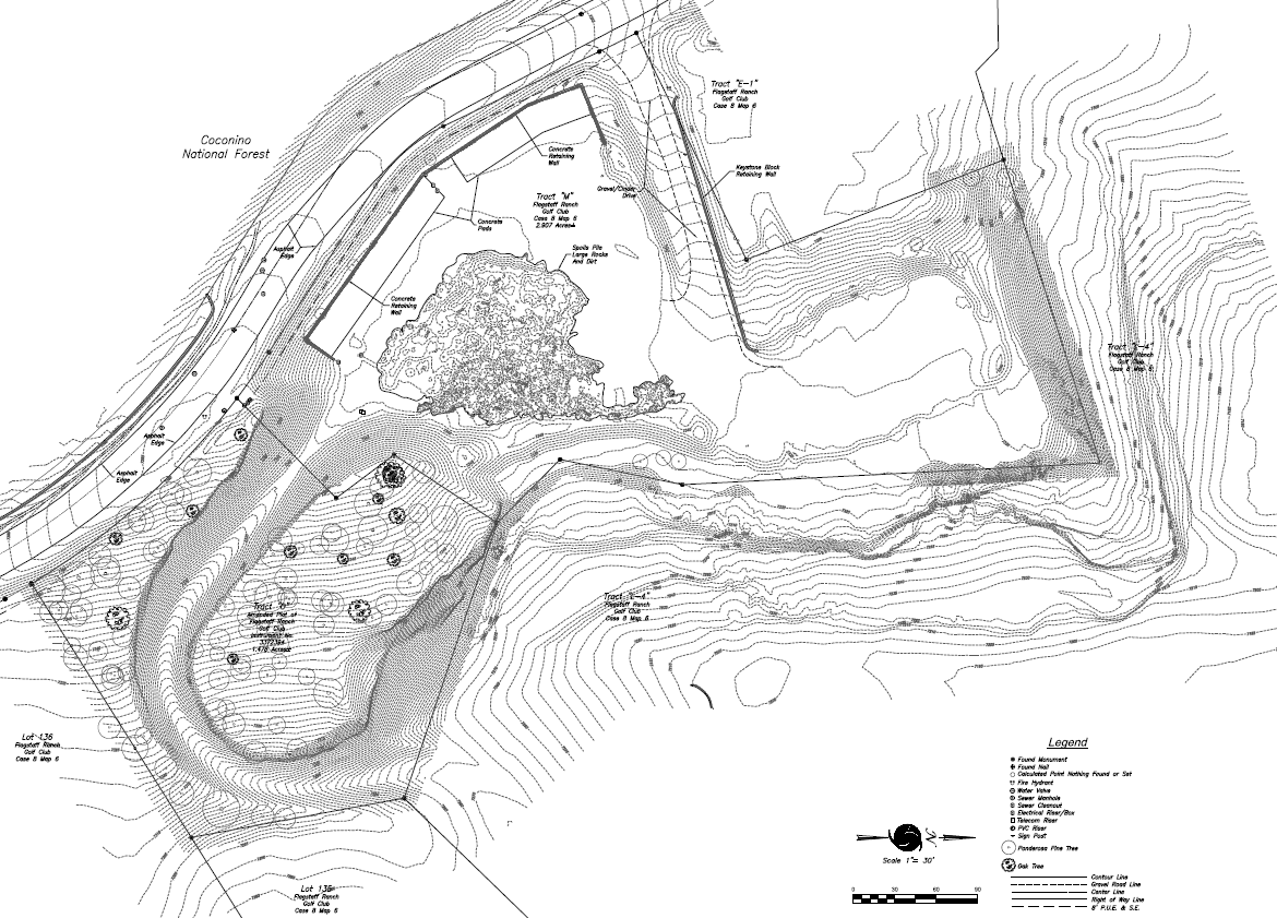
Most construction projects begin with a topographic map. A topographic map identifies and measures land features such as changes in elevation, man-made improvements along with trees, plants and shrubs. It provides design professionals with a digital representation of said features so they can plan and design improvements.
Thorough and accurate topographic mapping saves money from design phase all the way through construction phase of a land development project. Arizona Surveying has mapping experts trained to identify areas of concern that require detailed mapping like complex drainage areas. We have cutting-edge equipment and technology to achieve mapping accuracies needed for most applications.
Your mapping project will likely begin with a boundary survey that enables us to accurately represent mapping features relative to a parcel boundary, easement or right of way. From there we locate all relevant features to your project or specific needs. Then a map is produced which we then deliver printed and digital copies of to you and/or your design professional.
Conventional Topographic Mapping
A conventional topographic map is produced by either a one or two-man field crew measuring and collecting 3D data points with a survey instrument set up on your property. Depending on conditions, this generally takes a portion of a day to several days. Topographic mapping that takes much longer is generally done using other methods such as laser scanning, photogrammetry or aerial drone surveying.
Aerial drones are perfect for topographic mapping projects that are larger in scale, have difficult to access terrain or where there are safety issues for surveyors on the ground like active construction sites and mining/pit operations. Aerial drone mapping also offers the advantages of faster turnaround time, lower cost and more detailed modeling of site topography.
3D Laser Scanning (Lidar) mapping is recommended for sites and projects requiring highly accurate 3D models. Architects use it to map areas around buildings prior to design and remodel. Mining and pit operators value its efficiency and safety.
Some sites and projects are just too large to map efficiently with anything but aerial photogrammetry which is accomplished by flying manned aircraft over a site and taking high-resolution photographs. For these projects Arizona Surveying typically provides a boundary survey along with horizontal and vertical control data for the photogrammetric topographic map. We then work with a photogrammetric mapping company to acquire the aerial mapping data and map.
Typical Applications for Topographic Mapping
Pre-construction
Architectural design
Civil Engineering design
Environmental Restoration
Urban Planning
Mining Operations
GIS base mapping
Arizona Surveying Inc. is proud to offer topographic mapping services related to topographic survey, photogrammetry, aerial photogrammetry, GIS base mapping, Lidar mapping, environmental mapping, resource mapping, engineering mapping, aerial drone mapping in Flagstaff, Prescott, Sedona, Phoenix, Tempe, Glendale, Scottsdale, Casa Grande, Yuma, Tucson, Kingman, Laughlin, Grand Canyon, Navajo Reservation, Hopi Reservation, Hualapai Reservation, Coconino County, Yavapai County, Maricopa County, Pima County, Arizona, Utah, Colorado, New Mexico, Nevada and California.