
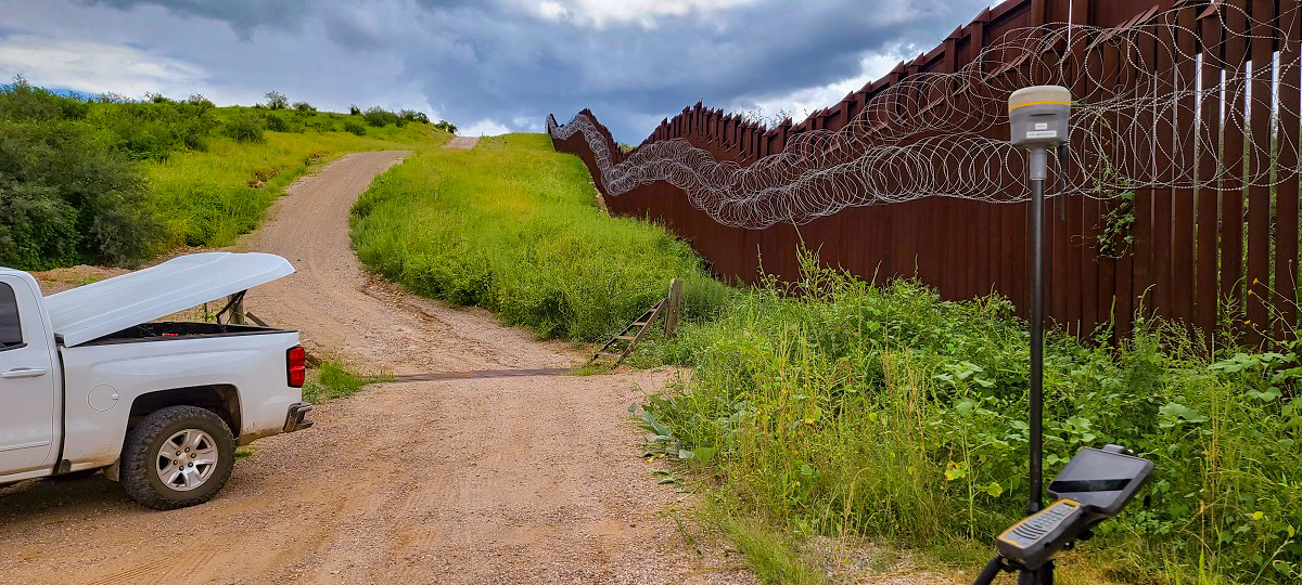
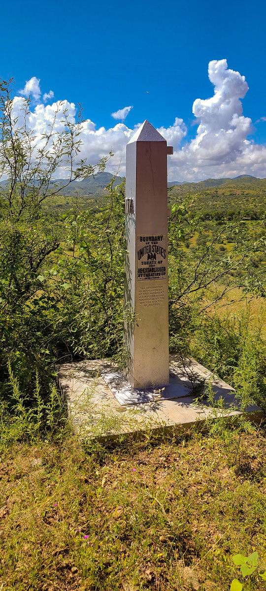
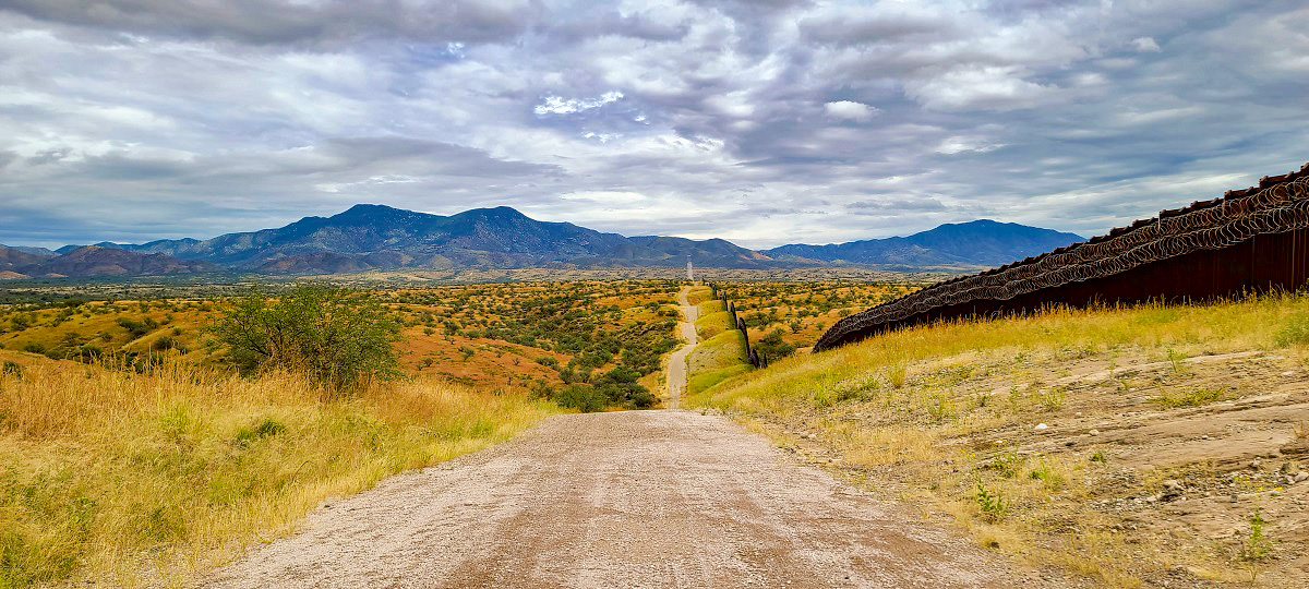
Arizona Surveying traveled to U.S./Mexico Boarder to perform a boundary survey for the City of Nogales to acquire approximate 2.70-acres. This area has a long history and we’re excited to be a part of it.
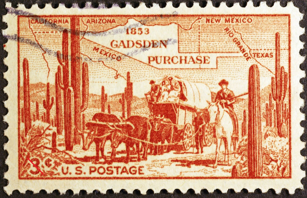
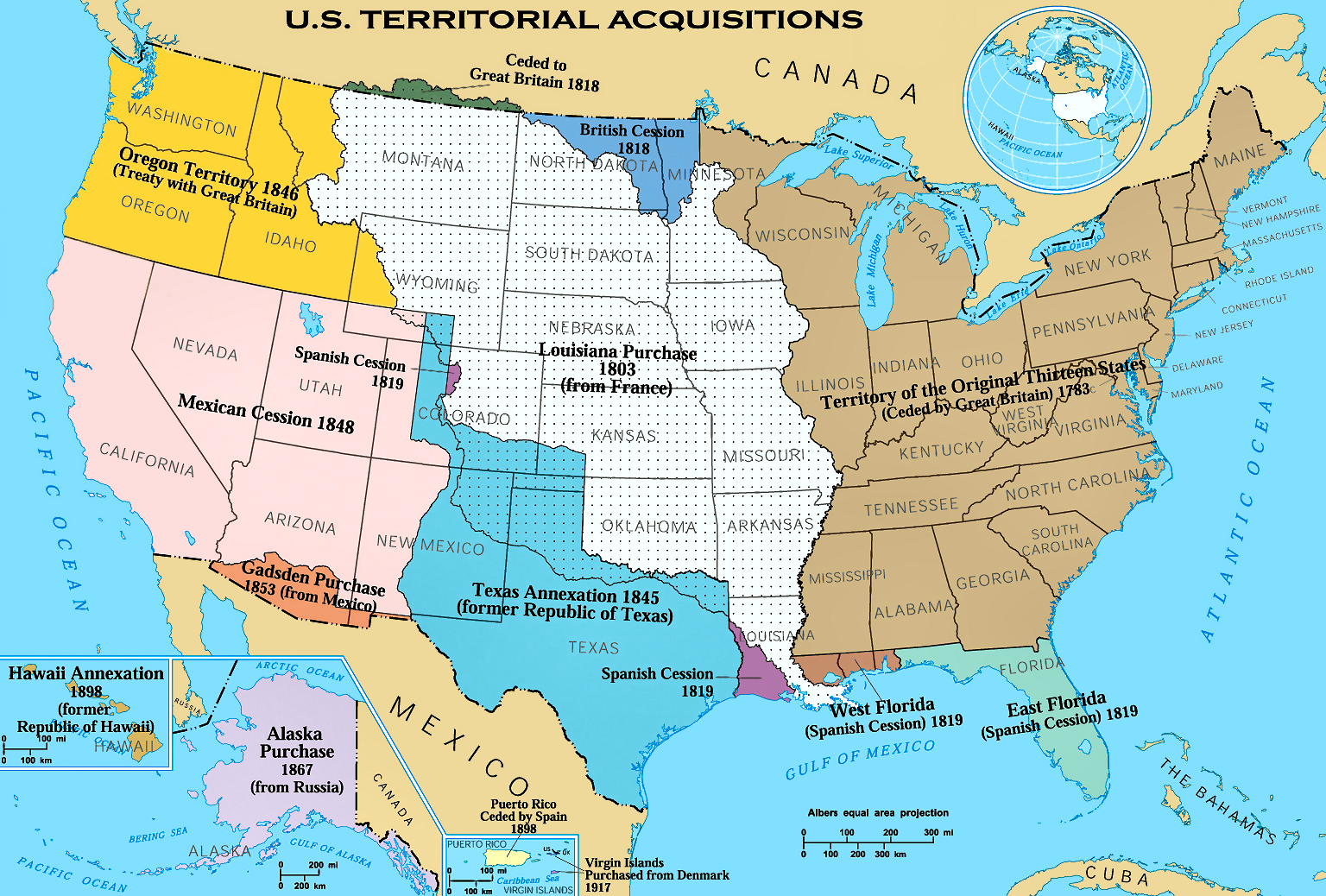
The Gadsden Purchase, or Treaty, was an agreement between the United States and Mexico, finalized in 1854, in which the United States agreed to pay Mexico $10 million for a 29,670 square mile portion of Mexico that later became part of Arizona and New Mexico. Gadsden’s Purchase provided the land necessary for a southern transcontinental railroad and attempted to resolve conflicts that lingered after the Mexican-American War.
 While the Treaty of Guadalupe Hidalgo formally ended the Mexican-American War in February 1848, tensions between the Governments of Mexico and the United States continued to simmer over the next six years. The two countries each claimed the Mesilla Valley as part of their own country. The Mexican Government demanded monetary compensation for Native American attacks in the region because, under the Treaty, the United States had agreed to protect Mexico from such attacks; however, the United States refused to comply, insisting that while they had agreed to protect Mexico from Native American attacks, they had not agreed to financially compensate for attacks that did occur. The persistent efforts of private American citizens to enter Mexico illegally and incite rebellions in an effort to gain territory exacerbated tensions between the governments.
These continuing tensions between Mexico and the United States complicated U.S. efforts to find a southern route for a transcontinental railroad as the only viable routes passed through Mexican territory. In 1847, the United States attempted to buy the Isthmus of Tehuantepec, an isthmus on the southern edge of North America, as an alternative means of providing a southern connection between the Atlantic and Pacific oceans. Mexico, however, had already granted Mexican Don José de Garay the right to build colonies for Americans on the isthmus with capital from the New Orleans Company. Fearing the colonists would rebel as those in Texas had, Mexican President Juan Ceballos revoked the grant, angering U.S. investors.
The treaty provided for a joint commission, made up of a surveyor and commissioner from each country, to determine the final boundary between the United States and Mexico. The treaty specified that the Rio Grande Boundary would veer west eight miles (13 km) north of El Paso. The treaty was based on the attached 1847 copy of a twenty-five-year-old map. Surveys revealed that El Paso was 36 miles (58 km) further south and 100 miles (160 km) further west than the map showed. Mexico favored the map, but the United States put faith in the results of the survey. The disputed territory involved a few thousand square miles and about 3,000 residents; more significantly, it included the Mesilla Valley. Bordering the Rio Grande, the valley consisted of flat desert land measuring about 50 miles (80 km), north to south, by 200 miles (320 km), east to west. This valley was essential for the construction of a transcontinental railroad using a southern route.
John Bartlett of Rhode Island, the United States negotiator, agreed to allow Mexico to retain the Mesilla Valley (setting the boundary at 32° 22′ N, north of the American claim 31° 52′ and at the easternmost part, also north of the Mexican-claimed boundary at 32° 15′) in exchange for a boundary that did not turn north until 110° W in order to include the Santa Rita Mountains, which were believed to have rich copper deposits, and some silver and gold which had not yet been mined. Southerners opposed this alternative because of its implication for the railroad, but President Fillmore supported it. Southerners in Congress prevented any action on the approval of this separate border treaty and eliminated further funding to survey the disputed borderland. Robert B. Campbell, a pro-railroad politician from Alabama, later replaced Bartlett. Mexico asserted that the commissioners’ determinations were valid and prepared to send in troops to enforce the unratified agreement.
In 1853, Mexican officials evicted Americans from their property in the disputed Mesilla Valley. When the U.S. Government did not act, Governor William Lane of New Mexico declared the Mesilla Valley part of the U.S. territory of New Mexico. Mexican President Antonio de Santa Anna responded by sending troops into the valley. Attempting to defuse the situation, U.S. President Franklin Pierce sent James Gadsden, the new U.S. Minister to Mexico, to negotiate with Santa Anna. Secretary of State William Marcy instructed Gadsden to renegotiate a border that provided a route for a southern railroad, arrange for a release of U.S. financial obligations for Native American attacks, and settle the monetary claims between the countries related to the Garay project.
Gadsden met with Santa Anna on September 25, 1853. President Pierce sent verbal instructions for Gadsden through Christopher Ward, an agent for U.S. investors in the Garay project, giving Gadsden negotiating options ranging from $50 million for lower California and a large portion of northern Mexico to $15 million for a smaller land deal that would still provide for a southern 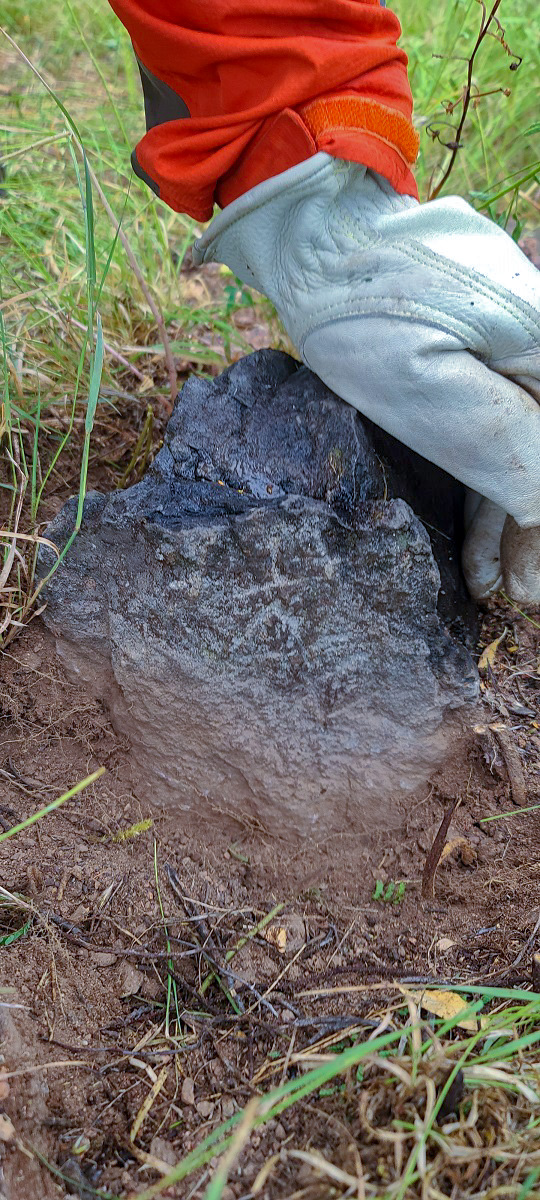 railroad. Ward also lied to Gadsden, stating the President wanted the claims of the Garay party addressed in any treaty concluded with the Mexican Government; however, President Pierce never gave Ward these instructions because he did not believe in government involvement in affairs between private companies and foreign governments. Santa Anna refused to sell a large portion of Mexico, but he needed money to fund an army to put down ongoing rebellions, so on December 30, 1853 he and Gadsden signed a treaty stipulating that the United States would pay $15 million for 45,000 square miles south of the New Mexico territory and assume private American claims, including those related to the Garay deal. The United States Government agreed to work toward preventing American raids along Mexico’s border and Mexico voided U.S. responsibility for Native American attacks.
With a great deal of difficulty resulting from the increasing strife between the northern and southern states, the U.S. Senate ratified a revised treaty on April 25, 1854. The new treaty reduced the amount paid to Mexico to $10 million and the land purchased to 29,670 square miles, and removed any mention of Native American attacks and private claims. President Pierce signed the treaty and Gadsden presented the new treaty to Santa Anna, who signed it on June 8, 1854.
After Gadsden’s Purchase a new border dispute caused tension over the United States’ payment, and the treaty failed to resolve the issues surrounding financial claims and border attacks. However, it did create the southern border of the present-day United States, despite the beliefs of the vast majority of policymakers at the time who thought the United States would eventually expand further into Mexico.
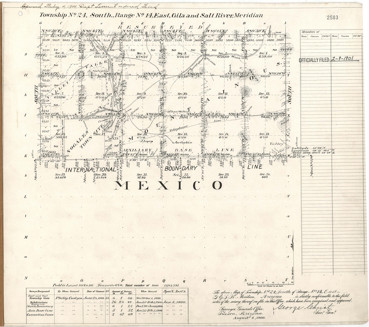
Today we can still remnants of these old surveys in the forms of stones which pre-date our modern brass caps. Along with copies of the original field notes and hand drawn maps Arizona Surveying was able to retrace the history of this area.
“Gadsden Purchase, 1853–1854.” U.S. Department of State, U.S. Department of State, https://history.state.gov/milestones/1830-1860/gadsden-purchase.